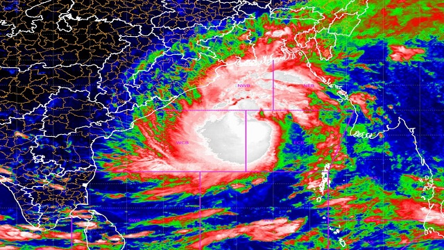
Bhubaneswar: The cyclonic storm “DANA” (pronounced as Dana) over Eastcentral Bay of Bengal moved northwestwards with a speed of 12 kmph during past 6 hours and lay centred over the eastcentral & adjoining westcentral Bay of Bengal near latitude 16.9° N and longitude 89.1°E, about 460 km southeast of Paradip (Odisha), 490 km south-southeast of Dhamara (Odisha) and 540 km south-southeast of Sagar Island (West Bengal).
It is very likely to move northwestwards and intensify into a severe cyclonic storm over northwest Bay of Bengal by early morning of 24th and cross north Odisha and West Bengal coasts between Puri and Sagar Island close to Bhitarkanika and Dhamara (Odisha) during night of 24th to morning of 25th October, 2024 as a severe Cyclonic Storm with a wind speed of 100-110 kmph gusting 120 kmph.
Forecast track and intensity are given in the following tables:
Cyclone update
Forecast in association with anticipated system:
Day -1: (Valid from 8.30 AM up to 8.30 AM of 24.10.24) Light to moderate rain/thundershower very likely to occur at many places over the districts of coastal Odisha and at a few places over the districts of interior Odisha.
Day -2: (Valid from 8.30 AM of 24.10.24 to 8.30 AM of 25.10.24) Light to moderate rain/thundershower very likely to occur at most places in the districts of north Odisha and many places in the districts of south Odisha.
Day -3: (Valid from 8.30 AM of 25.10.24 to 8.30 AM of 26.10.24) Light to moderate rain/thundershower very likely to occur at most places in the districts of Odisha.
Day -4: (Valid from 8.30 AM of 25.10.24 to 8.30 AM of 26.10.24) Light to moderate rain/thundershower very likely to occur at a few places in the districts of north Odisha and at one or two places in the districts of South Odisha.
Heavy rainfall warning for next four days as follows:
Day-1: (Valid upto 8.30 AM of 24.10.24.)
Yellow Warning (Be Aware) Heavy rainfall (7 to 11cm) very likely to occur at isolated places in the districts of Balasore, Bhadrak, Jagatsinghpur, Kendrapada, Puri, Jajpur, Cuttack, Khordha, Ganjam and Mayurbhanj.
Day-2: (Valid from 8.30 AM of 24.10.24 to 8.30 AM of 25.10.24.):
Red warning (Take Action) Scattered heavy to very heavy rainfall (7 to 20cm) with isolated extremely heavy rainfall (>20cm) falls very likely to occur in the districts of Jagatsinghpur, Kendrapada, Cuttack, Bhadrak, Jajpur, Balasore, and Mayurbhanj.
Orange warning (Be Prepared to take action) Heavy to very heavy rainfall (7 to 20cm) very likely to occur at isolated places in the districts of Puri, Khordha, Keonjhar, Nayagarh and Dhenkanal.
Yellow Warning (Be Aware) Heavy rainfall (7 to 11cm) very likely to occur at isolated places in the districts of Ganjam, Boudh, Angul, Deogarh, Sundargarh and Kandhamal.
Day-3: (Valid from 8.30 AM of 25.10.24 to 8.30 AM of 26.10.24.):
Red warning (Take Action) Scattered heavy to very heavy falls (7 to 20cm) with isolated extremely heavy rainfall (>20cm) very likely to occur at isolated places in the districts of Mayurbhanj, Keonjhar, Balasore, Bhadrak.
Orange warning (Be Prepared to take action) Heavy to very heavy rainfall (7 to 20cm) very likely to occur at isolated places in the districts of Jajpur, Kendrapada, Dhenkanal, Angul, Cuttack and Jagatsinghpur.
Yellow Warning (Be Aware) Heavy rainfall (7 to 11cm) very likely to occur at isolated places in the districts of Sundargarh, Sambalpur, Deogarh, Khordha, Jharsuguda and Puri.
Day-4: (Valid from 8.30 AM of 26.10.24 to 8.30 AM of 27.10.24.):
Yellow Warning (Be Aware) Heavy rainfall (7 to 11cm) very likely to occur at isolated places in the districts of Sundargarh, Keonjhar, Mayurbhanj and Balasore.
N.B.: Wind Warning for land area of Odisha state is depicted in the picture attached map Wind Warning for sea area & Sea conditions:
Sea Area Wind Warning Sea Conditions
Eastcentral Bay of Bengal
Gale wind speed reaching 75-85 kmph gusting to 95 kmph is prevailing and likely to increase becoming 80-90 kmph gusting to 100 kmph from 23rd evening till 24th morning. It is likely to decrease thereafter. Sea condition is likely to be high till 24th October evening and improve gradually thereafter.
West central Bay of Bengal
Gale wind speed reaching 65-75 kmph gusting to 85 kmph is prevailing. It is likely to increase gradually becoming 80-90 kmph gusting to 100 kmph from 23rd afternoon and 90-100 kmph gusting to 110 kmph from 24th morning till 24th afternoon. It is likely to decrease thereafter. Sea condition is likely to be very Rough to high on 23rd and high till 24th October evening. It is likely to improve gradually thereafter.
Northwest Bay of Bengal Squally wind speed reaching 45-55 kmph gusting to 65 kmph is prevailing. It is very likely to increase gradually becoming Gale wind speed reaching 70-90 kmph gusting to 100 kmph from 23rd evening till 24th night and thereafter 100-110 kmph gusting to 120 kmph till 25th Oct morning. It is likely to decrease gradually thereafter. Sea condition is likely to be Very Rough till 23rd evening and would become High to Very High from 23rd night till 25 th morning and improve gradually thereafter.
Northeast Bay of Bengal
Squally wind speed reaching 45-55 kmph gusting to 60 kmph is very likely to commence from 23rd night, becoming 50-60 kmph gusting to 70 kmph from 24th till 25th morning and decrease gradually thereafter. Sea condition is likely to be Rough to Very Rough from 23rd night till 25th morning and improve gradually thereafter.
Along & off Odisha coasts Squally wind speed reaching 45-55 gusting to 65 kmph is prevailing. It would gradually increase becoming gale wind speed reaching 60-70kmph gusting to 80 kmph from 24th morning and 100-110 kmph gusting to 120 kmph along & off north Odisha Gale wind speed reaching 60-80 kmph gusting to 90 kmph is likely along & off south Odisha from 24th night till 25th Oct morning and decrease gradually thereafter. Rough to Very Rough Sea condition is prevailing and likely to become High to Very High from 24th October morning to 25th Oct forenoon and improve gradually thereafter.
Fishermen Warning:
Fishermen are advised not to venture into
Eastcentral Bay of Bengal till 24th October.
Adjoining areas of Westcentral Bay of Bengal till 24th Oct.
North Bay of Bengal and along & off Odisha during 23rd to 25th October.
Port Warning:
KEEP HOISTED GREAT DANGER SIGNAL NO-10 (GD-10) at Puri, Dhamara/ Chandbali , Paradip and GREAT DANGER SIGNAL-08(GD-08) at Gopalpur port of Odisha.
Storm surge warning:
Storm surge is likely to be 1.0 to 2.0 m height above astronomical tide and very likely to inundate low lying areas of Kendrapara, Bhadrak & Balasore districts of Odisha during the time of landfall.
Storm surge of 0.5 to 1.0 m height above astronomical tide very likely to inundate low lying areas of Jagatsingpur district of Odisha during the time of landfall.
Impact Expected over districts of Odisha (Balasore, Bhadrak, Kendrapara, Jagatsinghpur, Puri, Khorda, Mayurbhanj, Kenonjhar, Jajpur, Cuttack, Dhenkanal).
Major damage to thatched houses/ huts. Roof tops may blow off. Unattached metal sheets may fly.
Minor damage to power and communication lines.
Major damage to Kutcha and some damage to Pucca roads. Flooding of escape routes.
Possibilities of damage to vulnerable structure. Breaking of tree branches and uprooting of trees.
Moderate damage to banana and papaya trees. Large dead limbs blown from trees.
Damage to horticulture and standing crops in some areas due to inundation and wind.
Damage to embankments/ salt pans.
Localized Flooding of roads, water logging in low lying areas and closure of underpasses mainly in urban areas of the above region.
Occasional reduction in visibility due to heavy rainfall.
Disruption of traffic in major cities and roadways due to water logging in roads and poor visibility due to heavy rain leading to increased travel time and incidents
Localized Landslides/Mudslides/landslips/mud slips/land sinks/mud sinks.
Likely disruption of marine and inland water transportation like small boats and trawlers.
It may lead to riverine flooding in some river catchments (for riverine flooding please visit Webpage of Central Water Commission).
Action Suggested (Balasore, Bhadrak, Kendrapara, Jagatsinghpur, Puri, Khorda, 12 Mayurbhanj, Kenonjhar, Jajpur, Cuttack, Dhenkanal):
TOTAL SUSPENSION OF FISHING OPERATIONS DURING 22ND TO 25TH OCT OVER CENTRAL AND NORTH BAY OF BENGAL.
Movement in motor boats unsafe
Coastal hutment dwellers to be moved to safer places.
People in affected areas to remain indoors.
Judicious regulation of onshore/offshore, Port and maritime activities including shipping.
Judicious regulation of tourism activities in Andaman & Nicobar Islands.
Judicious regulation of surface transports including railways and roadways.
Check for traffic congestion on your route before leaving for your destination.
Follow any traffic advisories that are issued in this regard.
Avoid going to areas that face the water logging problems often.
Avoid staying in vulnerable structure.